It’s the Right Place and Right Time for Geo-location Timelines
I had the opportunity to test out the myHisto app. This app is an interactive visual storytelling tool that combines blogging, timelines and geo-location tagging and mapping. I was first intrigued by geo-tagging for the classroom when Google maps allowed users to add rich media to map locations. It was fairly useful as part of any lesson plan that dealt with location or mapping.
myHistro really takes that to a new level, though. It’s narrative timeline with geo-tagging can, in fact, be the lesson. To get a better idea of why myHistro does at its website, take one of the timelines for a test drive. Just click the play button below:
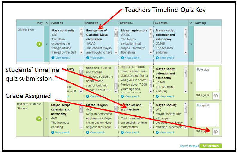
This is what makes myHistro really stand out, though: myHistro Extended is now part of the Edmodo app store. It works seamlessly within Edmodo, has a testing feature, and syncs with the gradebook. Pretty cool. The testing feature is unique. Students will need to recreate the timeline for the quiz, not just know timeline facts. Here’s the Edmodo gradebook view:
Katre Laan, myHistro’s Communication Officer, says “The initial idea was created with an aim to simplify and understand history through visualisation and interactive storytelling, and to introduce teachers to a tool that enables creating easy and interesting content whilst integrating technology into curriculum. myHistro is based on the same foundation as its forerunner, Histrodamus.”
In Edmodo, teachers can create their own timelines using myHistro Extended, and they also have access to literally thousands of timelines that have already been created by historians. The app bills itself as being great for history, geography, and social science teachers, but as a map lover myself, I believe you can use this app with virtually any course.
Science teachers could use a geo-location timeline when they are teaching about famous scientists, where they were from, and where they were when they made their discoveries. The geo-location timeline helps make the “far away” seem more up close and personal. Maps, images, and videos all help give a more complete picture. Science teachers can also easily make an event driven timeline:
Literature, no problem. Check out this great Huck Finn timeline in myHistro:
Mathletes, I knew you would say no way could you make use of a geo-location timeline, so I created one myself just for you.
Students can create their own timelines, as well. This app is an engaging “DO” activity for students. It’s important for students to be able to construct a narrative and have the skills to deliver that narrative visually. They also need to be able to visualize change over time. The app allows students to organize information in their timelines (text content, dates, geo-location, links, images, videos) and showcase their finished products.
It’s also important that students understand the dynamics between information, time and location, and how their construction affects the narrative of a story or flow of information. Simple for us. Maybe. Mastered by students. Seldom.
A great tool to pair with myHistro is the visualized research tool instaGrok. Have students research and collect their data on instaGrok (also in the Edmodo app store) and then bring that research data into myHistro.
I also like apps and resources that crowdsource lessons for teacher. Not only do teachers have access to thousands of timelines in the myHistro library, they can make their own timelines public so that other teachers can use. Our collective crowd resources can be quite impressive.

0 Comments
Leave a Comment
Your email address will not be published. All fields are required.